Day 12 – Dinosaur national park
Date: 06/13/2016 Monday
Starting Location: Boulder, CO
Ending Location: Vernal, UT
Starting Odometer: 9206
Ending Odometer: 9663
Mileage Today: 370 Miles
Mileage Total: 2809.7 miles
Today’s MPG: 41 mpg
Total Average MPG: 43 mpg
Leaving Boulder
Jim got up at 5AM to see me on my way, having breakfast with me at a local coffee shop before I gassed up, and headed for UT. I was able to leave the coffee shop by 6:15, 45 minutes ahead of schedule. The temperature in Boulder when I left was a very reasonable 58 degrees.
The route choices
In essence, there are two ways to leave Boulder, and make your way to UT. You can either go North, and make your way through Rocky National Park, or you can go South, eventually arriving at Interstate 70, traveling it for about 15 miles before heading North again. Jim suggested that the route through Rocky Mountain National park would be best, but the GPS had already chosen the southern route. If I wanted to change it, I would need to load intermediate way points into the GPS that force it to select the Northern route. I did not have the time, nor the inclination, so i let the GPS take me South.
The route to I-70 was great. There were about 45 miles of windy roads, with almost no traffic. It’s hard to imagine that the Northern route would have been more beautiful, but Jim’s been right on everything else so far, so there is no need to doubt him. It is hard to believe that the other route could have been any better, none the less.
Once I left I-70, and after a few quick turns, I ended up on Colorado route 40. I would come to take this route for another 270 miles or more before I arrived in Vernal, UT.
Dinosaur National park – Next stop
I was going to need to travel about 300 miles before arriving at Dinosaur national park. So, I made my way West, enjoying the day, but as I’ve done a few other times on this trip, I did not wear my base layer, so as the temperature dipped, I started to get cold. Once again my optimism about the temperature proved to be my undoing. I made it all the way to Steamboat Springs before I stopped to put on my layer.
I stopped at a gas station with a bakery and coffee shop, and had what they called a Cowboy Cookie. All I could think of is that I’m never going to be able to quit those cowboy cookies. It was awesome!
Dinosaur National Park – The three entrances
There are essentially three ways to enter Dinosaur National Park. The first entrance is in CO, off of Rt 40. This road leads you into the park, but not to a Visitor Center. The second entrance is still in CO, and it leads you to a Visitor center, and is just off of Rt 40. The third entrance is about 40 miles further on Rt 40, and it is in UT.
I entered the park at the 2nd entrance, and talked to the ranger. It seems that the big attraction for this park would be at the Visitor Center in UT. But, (the ranger said…), there are some great wildlife sightings if you travel in this side of the park, taking the main road 31 miles to the end, and then returning on the same road.
I looked at the map, and asked… What is this road over here. It looks like dirt. Does it connect to the other Visitor Center in UT?
The ranger said yes it does, but it is a treacherous road, and the first section is simply unpaved, but the second and third sections get progressively more difficult, and more technical. She said that some time back another motorcyclist told her it took three hours to travel this road, and that she should never send anyone on this road ever again. He said it was virtually unpassable.
Well, those were just the words that I needed to hear. With a smile on my face, I proclaimed that it would take me about 45 minutes, or maybe an hour, but certainly no longer than that.
So, I did my best to memorize the map, and off I went. At about mile marker 20, I turned left onto the dirt road, and started my cross-country journey.
OMG – She’s not kidding…
The road started out as simple dirt road, which was not marked well at all. Within .1 miles from the main road, I had already been confronted with a choice that was not on the original map. I took a wrong turn, traveled about a mile, and then turned around to correct my mistake.
The road was a reasonable dirt road, gradually adding small pockets of loose gravel and sand. As the distance from the main road increased, the amount of sand and gravel increased, but it was still quite manageable. After another wrong turn, with another correction/back-track, I was finally on the right road, headed into the Valley below.
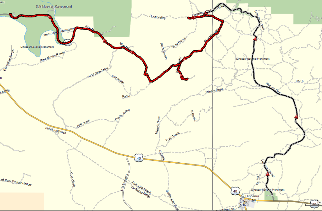
I’ve included a picture of the route from one Visitor Center to the other.
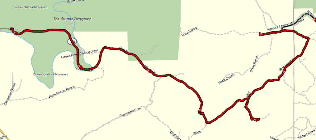
And here is a more detailed look at the section that is dirt, or gravel.
Along the way there were numerous herds of cows, all of whom seem to respond properly to the beep of a horn.
The amount of, frequency of, and depth of the sand was ever-increasing, and by the midpoint, the road had become fairly technical. As I finally made my way to the last remote turn-off, i saw a sign for Rt 1550, which I believed to the correct road. I turned right, and began the descent into the valley below.
This road proved to be very technical and very difficult. There were two basic problems. First of all, as a solo traveler, I could not afford to make a mistake. Even the smallest error could land me and the bike on the ground, and depending on how the bike ended up, it might not be possible to extract it. So, I needed to keep my wits and ride with the knowledge and intent of a pro.
The descent was quite steep, and the trail became very rocky, with steep drop-offs on the outside (right side) of the trail. There was one section (you can hear me agonizing over this section in the video) where I had slow down to almost a standstill so that I could move the bike around the obstacles (rocks, gravel, holes, ruts, drop-offs) without falling.
In a situation like this, you can drag the back brake, but the bike will eventually slide out to one side or the other, so you need to control your slide. You also need to be very careful not to lock the front wheel, as sliding the front wheel will almost certainly cause the bike to go down. So, there I was applying everything I had learned in the two off-road riding classes that i attended at Rawhyde.
While it was tough, and mentally and physically challenging, I kept my wits, and simply executed the moves, at the right time. I captured video footage of most of the trip, and the best I can figure is that the route from start to finish took me about 2 hours and 30 minutes.
The video does not really do the ride justice, but I hope that you enjoy how the route developed and how my mood was altered as I confronted the obstacles one after another.
I hope you enjoy the film. it’s about 20 minutes long, and represents the first real adventure of this trip.
Dinosaur National Park – UT Visitor Center
I spent about 2 hours at the UT Visitor Center for the park. During that period, I had a chance to look at the wall of fossils. As it turns out, this wall of fossils was once a layer of soil, parallel to the ground. In fact, it was the ground.
Eventually, pressure under the Earth pushed up the land, and this piece of ground slowly rose until it was vertical, instead of being horizontal. As a result, there is a wall that is right there in front of you, which contains about 1500 fossilized bones.
I’ve taken a number of pictures, and put them in the gallery below.
The hotel in Vernal
The hotel in vernal is the Microtel Suites hotel. This is probably the best hotel of the trip so far. I think this hotel must be brand new, as the rooms are clean, and everything is brand new.
What’s on store for tomorrow
To be honest, the rendering this video took about 3-4 hours, so I have not had a real chance to review my route for tomorrow. The good news is that I’ll just be traveling to my next transition point, and there are no real sightseeing possibilities. I’ll travel about 275 miles, and then settle in to update the routes on my GPS.


LOL at “huh… This is going to take awhile…”